The Future of Franconia Ridge Trail Work

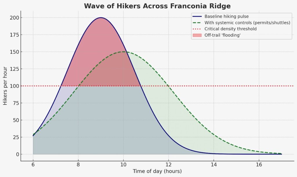
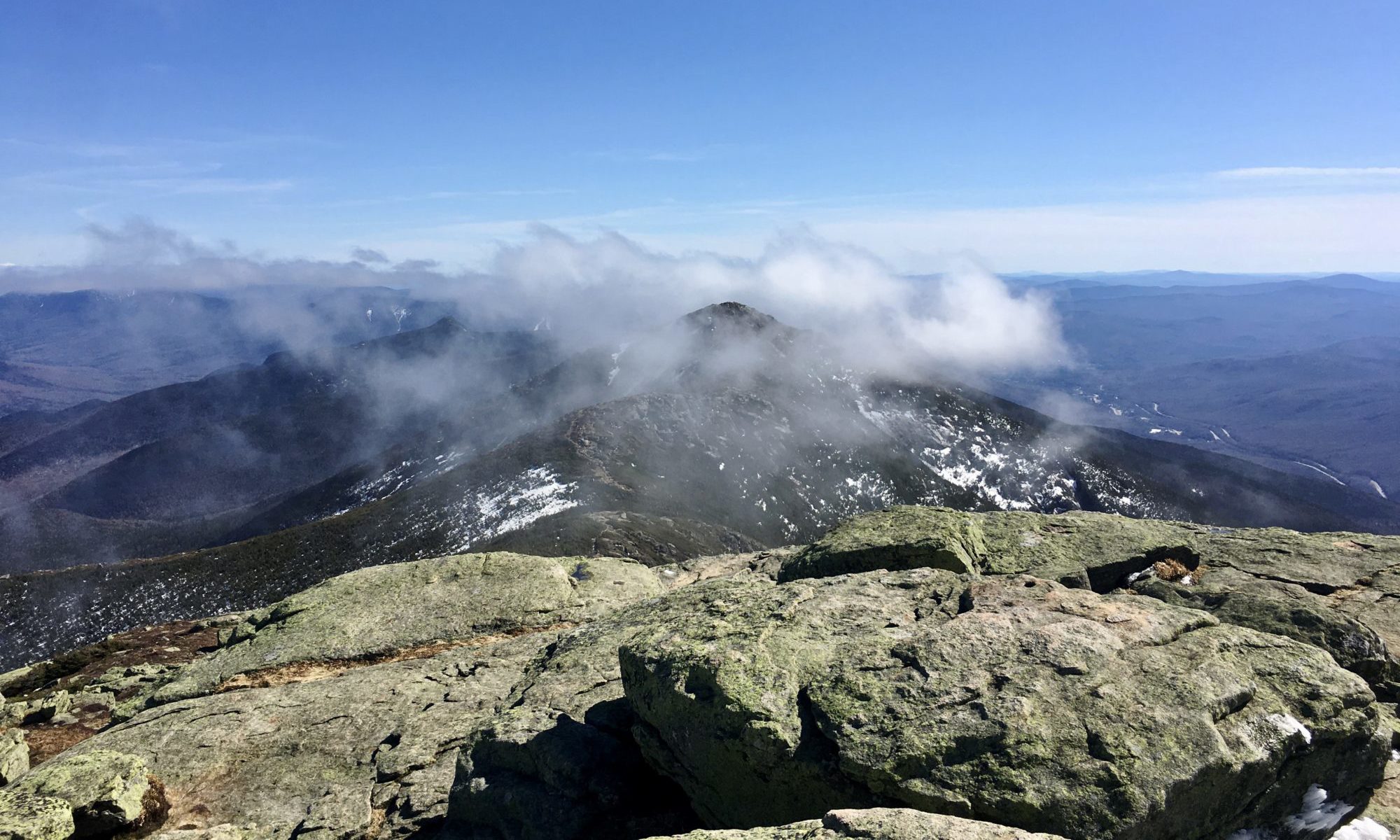
As we complete the fourth year of the Partnership to Restore Franconia Ridge (third year for Pan American Trails/WTN Americas), it is increasingly clear that the existing federal funds will not support significant improvements to the Franconia Ridge Trail itself. 1 The $1.125 million in federal money secured through the AMC with the help of Senator Shaheen will soon run out, and the private funds Pan American Trails/WTN Americas has raised are directed toward the Old Bridle Path and Falling Waters Trail in Franconia Notch State Park—below the alpine zone.

This project was named for Franconia Ridge and justified in part as a way to protect its fragile alpine area. Yet by improving the two main access trails, we risk funneling even more people into the alpine zone. Unless the USFS and Franconia Notch State Park take action to limit use, or we redesign the Ridge trail to accommodate current numbers, the alpine zone will deteriorate further.

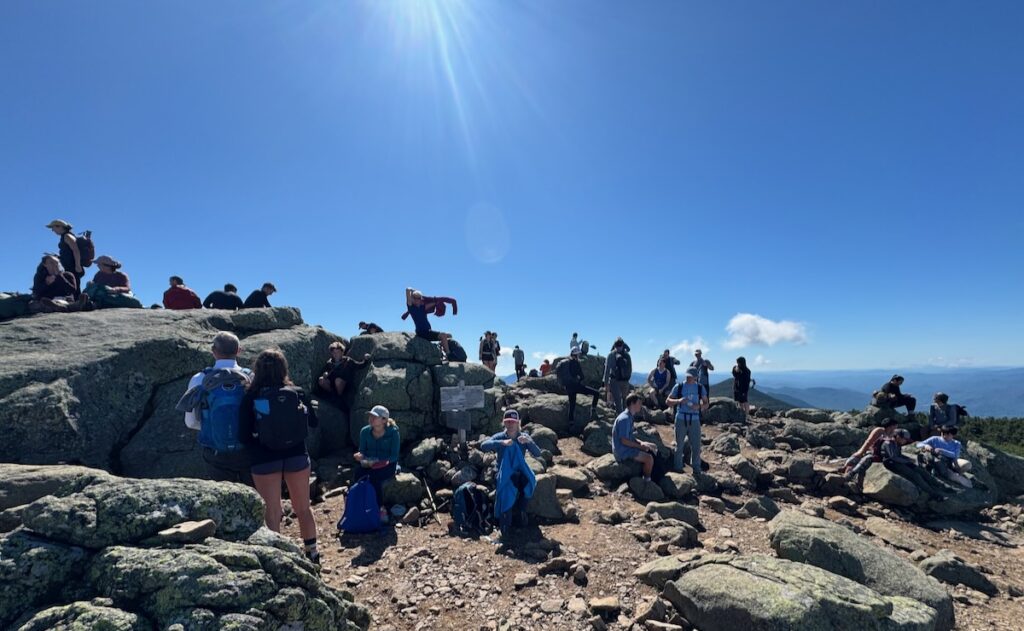
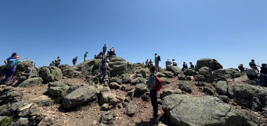
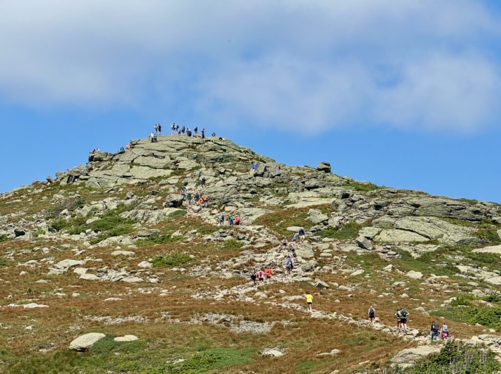
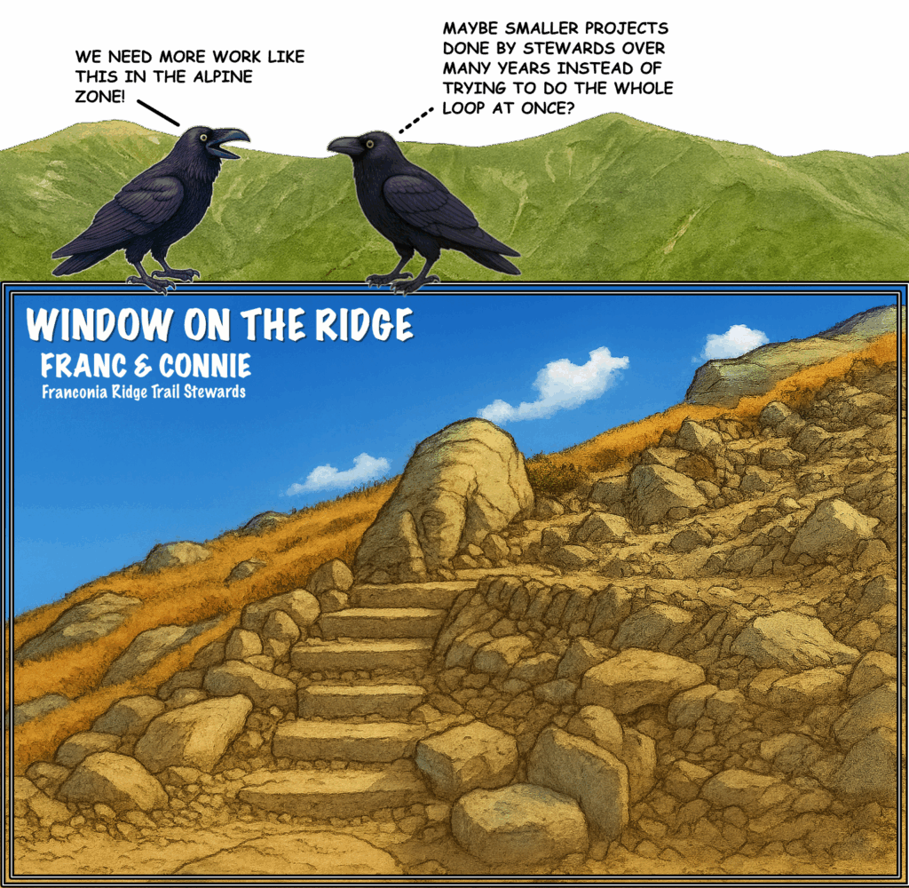
A Trail Exceeding Capacity

The research and monitoring of Pan American Trails/WTN Americas Summit Stewards, students, and Trails Fellows show what many of us witness every weekend: Franconia Ridge is often well beyond capacity. Without the presence of stewards on the Ridge—both Pan American Trails/WTN Americas’ professionals and AMC’s volunteers—the alpine zone would be even more deteriorated. It is constant work—maintaining scree walls, piling brush and rubbling trampled areas, adding string fencing—that keeps most visitors on the trail. Thanks to this stewardship, we now see stabilized soils and revegetation in some areas.

Even if new policies reduced visitation by a third, the Ridge would still require weekly tending and a permanent steward presence.

What the Franconia Ridge Needs

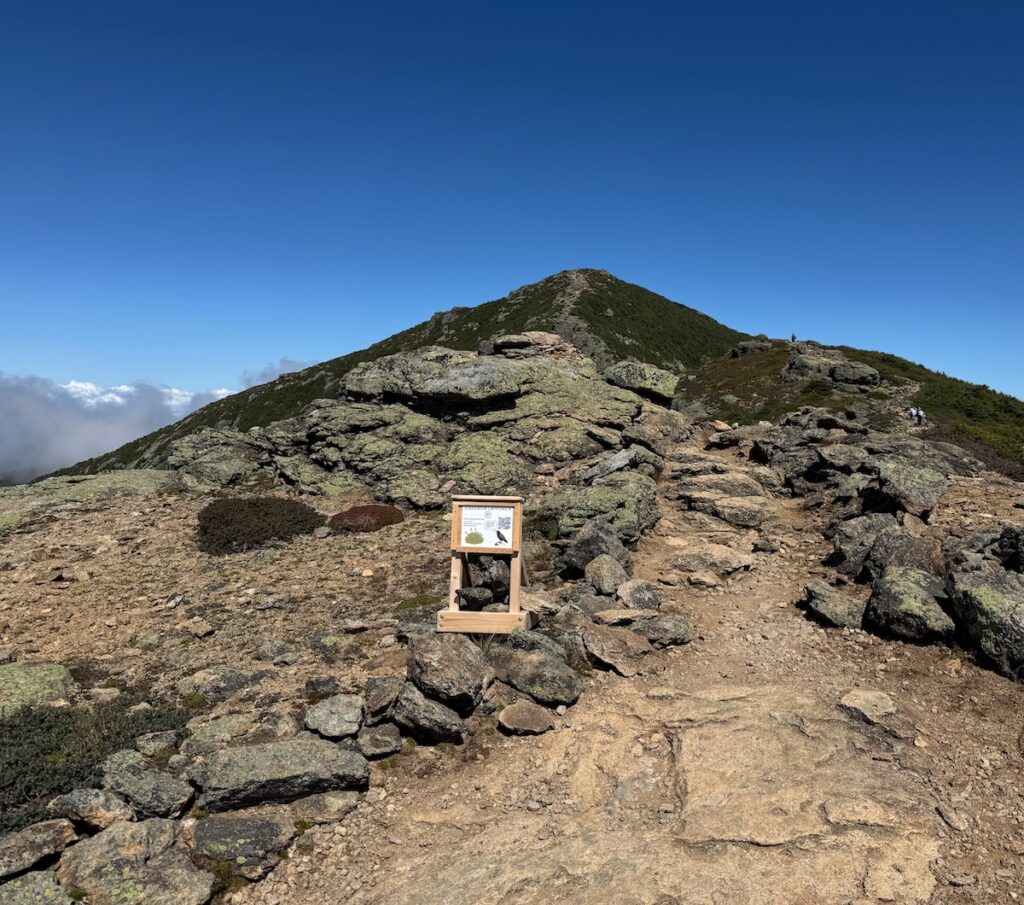
We do need thoughtful tread reconstruction on Franconia Ridge, but it must be carefully tailored to the Ridge’s geology, ecology, and visitor behavior. The first step is a detailed inventory of places where off-trail behavior consistently occurs: narrow pinch points, sections with high rugosity (protruding rocks in the tread), high steps, steep grades, and unclear boundaries.

From there, we can apply our recognized toolbox of solutions—widening the trail, adding pullouts, removing obstacles in the tread, rebuilding steps, short relocations, rebuilding scree walls, and installing string fencing. This should happen over time, not all at once.

Who should do this work? Small alpine-experienced crews—two or three people who understand how hikers move through this terrain. Their work could proceed slowly, section by section, integrated with ongoing maintenance and adjusted as they see what succeeds and what fails. In this way, a consistent annual program of trail repair becomes part of the fabric of stewardship—like the Golden Gate Bridge, which is painted continuously, this work never finishes.

Even the best-built drystone scree walls on Franconia Ridge begin to fall apart almost immediately when knocked by hikers and runners. High-quality rock steps shift and become undermined in just a few years, succumbing to gravity and the impact of 45,000 visitors a season. Trail work must be revisited, repaired, and sometimes redesigned and adapted to new patterns of use.

Summit Stewards are uniquely positioned to play this role. They already devote less busy days to trail work. With additional training, stewards could tackle more technical projects, like rebuilding rock steps.

And of course, there is string fencing to replace, waterbars to clean, and signage to refresh. Stewards currently complement trail work with indirect management: providing information, education, and interpretation to visitors; conducting environmental and social monitoring; leading volunteers; and working closely with AMC Alpine Stewards and USFS Trailhead Stewards. All of this is coordinated with and overseen by the USFS. Trail-based management is further complemented by administrative policies such as potential visitor use limits, group-size limits, and parking/shuttle management in Franconia Notch State Park.

Taken together, this is integrated trail management: trail tending.

The Limits of “Big Project, Big Funding”

This vision stands in contrast to the recent model of massive, multi-crew projects focused only on trail reconstruction. The Crawford Path project and the current Franconia Ridge partnership exemplify this “big project, big funding” approach. While it may sustain large trail departments, the results are mixed: work quality varies, and when the money runs out, crews disappear—finished or not. Worse, it feeds what I call the engineer’s conceit: the idea that if you just build a trail “right,” the job is done.

Good engineering and design do matter—Inca stonework in South America has endured for a thousand years, a testament to what careful construction can achieve. But no trail, however well built, is ever truly “finished.” Every trail requires constant revisiting, with regular maintenance, and adjustment and adaptation over time as climate and use patterns change. One reason so many White Mountain trails are in poor condition is that trail maintenance has been segregated from trail construction and reconstruction and treated as second-class work, rather than as the heart of stewardship.

The Role of Summit Stewards

Nearly five years ago, when “restoration” funds for the Franconia Ridge Loop first appeared, the Summit Steward program was excluded from sharing in the grant—because at the time the USFS and AMC did not consider stewardship “tread work.” I believed then, and still believe now, that this was a mistake. Over the four years of the partnership, it is Summit Stewards and volunteers who have in fact done the only tread work on the Franconia Ridge Trail itself.

Thankfully, the USFS has come to recognize this and has increased its funding for the Summit Steward program. The Waterman Fund has been a consistent supporter. Even so, it remains a struggle to find enough funds to keep Summit Stewards on Franconia Ridge every year.

Looking Forward

As the Partnership to Restore Franconia Ridge Loop winds down, we should not be chasing ever-larger grants to stage logistically complex projects that vanish when the money dries up. Instead, let’s invest in a dedicated cohort of specially trained Summit Stewards—small, skilled teams who can continually rebuild, adapt, and maintain the Franconia Ridge Trail.

The alpine zone demands nothing less.

  1. The Appalachian Mountain Club (AMC) professional crew did some excellent work building scree wall and and cairns on the summit of Lafayette and on the upper Greenleaf Trail, and recently an AMC led Vermont Youth Conservation Corp crew did equally high-quality work on the upper Greenleaf Trail. But no work has gone beyond the summit of Lafayette on the Franconia Ridge itself. ↩︎

Hiker Flow on Franconia Ridge: A Fluid Dynamics Analogy

From the September 3, 2025 issue of the Raven

A Chance Encounter

Over the last ten years of intensive focus on Franconia Ridge I have come to refer to the surge of hikers and runners that stewards see on popular weekend days as “the wave.” During seminars and while doing field work this year, students and trails fellows began to expand this analogy, seeing hikers “flow” across the Ridge and summits and pullouts as “eddies.”

A chance encounter on Franconia Ridge almost two weeks ago sparked me to take this analogy to a new level. I met a hiker whose field of expertise is in biosignal processing and nonlinear systems analysis, who studies physiological flows like heart rhythms and arterial turbulence. We corresponded after, and he asked if I thought the Navier–Stokes equations might apply to trails.

The Navier–Stokes equations are the fundamental mathematical description of how fluids (like air or water) move, capturing the balance between inertia, pressure, viscosity, and external forces. That question encouraged me to pull together a few ideas I’ve been developing over the decade and consider how this analogy might help us build a model for off-trail surges on Franconia Ridge.

Fluid Dynamics as Analogy

The Navier–Stokes equation can be a surprisingly useful analogy for hiker flow. At its core, fluid dynamics helps us think about how many individual “particles” moving together generate collective patterns like laminar flow, turbulence, eddies, and surges. Those patterns map well onto what we see on high-use trails: smooth movement when hikers are well spaced, congestion when they bunch up, and sudden bursts of off-trail departures when local density rises too high.

From Pipes, to Arteries, to Rivers

Pipes are rigid: too much pressure and they burst, too little and they collapse (Venturi effect). This is a binary, mechanical mode of failure — the pipe is intact, or it has catastrophically failed.

Arteries are elastic: adaptive, but also prone to nonlinear thresholds. Turbulence interacts with narrowing walls, so small changes in flow can lead to sudden constriction or occlusion. This resembles the way off-trail departures spike once density passes a tipping point (Lee et al., 2012).

Rivers are adaptive: porous banks allow flow to respond to terrain, and excess volume produces meanders and braids. Trails behave the same way: instead of bursting, they widen and braid under pressure (Wimpey & Marion, 2010).

This progression — pipe, artery, river — shows why rivers may be our best analogy, while physiology reinforces why nonlinear thresholds must be central to our models.

Thresholds and Nonlinear Dynamics on Franconia Ridge

Field observations align with this systems view. On busy weekends, the sequence:

A morning wave of hikers enters the loop, creating a density surge that moves across the Ridge like a flood pulse → At first, flow remains laminar: hikers stay mostly on-trail → Once a density threshold is exceeded, behavior changes suddenly: hikers step off to pass, to rest, or to avoid crowds → Off-trail departures spike nonlinearly, resembling a bifurcation event (Helbing et al., 2000) → Impacts grow disproportionately: a modest increase in hikers per hour results in a dramatic rise in trampling and braiding.

This is the hallmark of a complex adaptive system. Like turbulence in arteries or overbank flooding in rivers, trail impacts emerge abruptly once thresholds are crossed.

Above: Managers could try reducing the wave through timed entry or permits. In the above graph you can see this doesn’t necessarily get us out of the red zone (off-trail surge). Another approach would be to try to raise the critical density threshold through other direct management (widening the trail, adding string fencing, decreasing rugosity, etc.) or through indirect management (signs, stewards, education campaigns). If you would like to see how different management strategies and changing different variable, try this interactive model (click on graphic above). Note: this is a much simpler model than the ABM mentioned below.

Using Agent-Based Modeling to Anticipate Outcomes

Because averages obscure these nonlinear spikes, managers need modeling approaches that capture thresholds and feedback. Agent-based modeling (ABM) offers a promising tool.

How it works: each hiker is modeled as an “agent” with simple rules — walking speed, group size, comfort with crowding, probability of stepping off-trail under certain densities or slopes.

Wave dynamics: by varying start times at trailheads, the model can simulate the morning “pulse” of hikers moving across the Ridge, showing when and where local densities approach critical thresholds.

Threshold behaviors: ABM has already been used in visitor management for protected areas (Štekerová et al., 2022) and in crowd science to capture nonlinear “panic” or “jam” effects (Helbing et al., 2000). Similar approaches have shown how social groupings change crowd flow (Moussaïd et al., 2010) and how physiological factors shape pedestrian trajectories (Narang et al., 2015).

Testing interventions: scenarios can be run for permit or timed-entry systems, steward placement at key “eddies,” trail design changes, or communication tools like signage and steward contact.

This mirrors river management, where levees, diversions, and floodplains work together. It also reflects physiology, where resilience depends on both vessel walls and regulatory signals.

Interpretive sign in pull-out area

A Systemic View of the Loop

The river analogy encourages managers to take a whole-system view of the Franconia Ridge loop:

Inputs: parking, shuttles, and trailhead access determine the size and timing of the hiker “wave.”

Regulation: permits, timed-entry systems, shuttle timing can flatten the morning surge, lowering the chance of threshold crossing. 

Trail design: side-hill alignment, wider trails, scree walls, string fencing.

Local controls: stewards act as “regulators,” dampening turbulence at critical points and educating visitors.

Above treeline, where realignment away from fall-line routes may not be feasible, these systemic and social interventions are crucial to protecting the three miles of alpine zone on the Franconia Ridge Loop that are most at risk.

Conclusion

Trails behave less like pipes waiting to burst and more like rivers whose channels expand and braid under pressure. The artery analogy reminds us why thresholds matter: small changes can trigger nonlinear shifts with outsized impacts.

By adopting this systemic, nonlinear perspective, managers can better anticipate surges, identify bifurcation points, and deploy layered interventions. This is the essence of Integrated Trail Management (ITM): combining design, education, regulation, and stewardship to create resilience in the face of growing use.

Just as rivers are managed through levees, diversions, and floodplains, and arteries rely on both vessel strength and systemic regulation, Franconia Ridge can be managed through a mix of direct and indirect tools. The goal is not to eliminate flow, but to channel it wisely, preserving fragile alpine ecosystems.

Looking ahead, agent-based modeling (ABM) can help managers simulate how hikers move across the Ridge, anticipate where thresholds are crossed, and test interventions virtually before applying them on the ground. By linking trail design, administrative tools (permits, timed entry, shuttle schedules), and policy measures (group size limits, steward placement) into a single systemic framework, ABM provides a way to identify the most effective combinations. In this way, science, design, and governance reinforce one another — giving us a path toward both protecting the alpine zone and sustaining the experience of those who visit it.

References

Cole, D.N. (1995). Experimental trampling of vegetation: Predictors of resistance and resilience. Journal of Applied Ecology, 32, 215–224.

Helbing, D., Farkas, I., & Vicsek, T. (2000). Simulating dynamical features of escape panic. Nature, 407, 487–490. https://doi.org/10.1038/35035023

Marion, J.L. (2016). A review and synthesis of recreation ecology research supporting carrying capacity and visitor use management decisionmaking. Journal of Forestry, 114(3), 339–351.

Marion, J.L., Park, L.O., & Wimpey, J. (2022). Efficacy of Combining Education and Site Management in Reducing Off-Trail Travel in a Fragile Biotic Community, Acadia National Park. Journal of Interpretation Research, 28(1), 26–45.

Moussaïd, M., Perozo, N., Garnier, S., Helbing, D., & Theraulaz, G. (2010). The walking behaviour of pedestrian social groups and its impact on crowd dynamics. PLoS One, 5(4), e10047. https://doi.org/10.1371/journal.pone.0010047

Narang, S., Best, A., Curtis, S., & Manocha, D. (2015). Generating pedestrian trajectories consistent with the fundamental diagram based on physiological and psychological factors. PLoS One, 10(4), e0117856. https://doi.org/10.1371/journal.pone.0117856

Park, L.O., Manning, R.E., Marion, J.L., Lawson, S.R., & Jacobi, C. (2008). Managing visitor impacts in parks: A multi-method study of the effectiveness of alternative management practices. Journal of Park and Recreation Administration, 26(1), 97–121.

Rupf, R., Haegeli, P., Karlen, B., & Wyttenbach, M. (2019). Does Perceived Crowding Cause Winter Backcountry Recreationists to Displace? Mountain Research and Development, 39(1), R60.

Štekerová, K., Zelenka, J., & Kořínek, M. (2022). Agent-Based Modelling in Visitor Management of Protected Areas. Sustainability, 14(19), 11853. https://doi.org/10.3390/su141911853

Lee, J., Nemati, S., Silva, I., Edwards, B.A., Butler, J.P., & Malhotra, A. (2012). Transfer entropy estimation and directional coupling change detection in biomedical time series. Biomedical Engineering Online, 11(1), 19. https://doi.org/10.1186/1475-925X-11-19

Wimpey, J., & Marion, J.L. (2010). The influence of use, environmental and managerial factors on the width of recreational trails. Journal of Environmental Management, 91(9), 2028–2037. https://doi.org/10.1016/j.jenvman.2010.05.017

From only me, to we

“To begin with oneself, but not to end with oneself; to start from oneself, but not to aim at oneself; to comprehend oneself, but not to be preoccupied with oneself.”
— Martin Buber

Jess and Demi’s reports and photos from last weekend on Franconia Ridge left me disheartened. Graffiti on rocks and ledges, an abandoned tent in the alpine zone, the usual overcrowded summits—and then, astonishingly, someone who had hauled a rowing machine to the ridge. Taken together, these images left me stunned. I try to recognize that people experience and enjoy the outdoors in different ways—often very different from what I would choose. But the risk in sliding too far into relativism is that we lose our ethical grounding.

Aldo Leopold offers one of the simplest and most direct definitions of ethics: 

“All ethics so far evolved rest upon a single premise: that the individual is a member of a community of interdependent parts. His instincts prompt him to compete for his place in that community, but his ethics prompt him also to cooperate…”

In one of the graffiti scrawls I saw the words “Only me.” Whether that was what the author intended to write, it seemed fitting: a declaration of narcissism. In a world of “only me,” there is no community, no sense of responsibility, no ethics.

Leopold believed ethics can and must expand beyond human-to-human relations: “The land ethic simply enlarges the boundaries of the community to include soils, waters, plants, and animals, or collectively: the land.”

To stand on Franconia Ridge is to recognize and respect not just the thousands of fellow hikers, but also the alpine plants, the ravens and other wildlife, the thin, fragile soils, the brooks and streams rushing down into the Pemigewasset Wilderness. All are part of our community.

Trophies

Leopold also spoke of a conservation “esthetic,” the idea that recreation in nature could cultivate deeper values. He discussed how seeking “trophies” can connect people to the land. He distinguished between direct and indirect trophies.

A direct trophy is something extracted from the land—antlers, a trout, a pressed flower. This can be sustainable when taken sparingly, but they consume what they commemorate. By contrast, an indirect trophy—a photograph, a field sketch, a journal entry—leaves the land intact. For Leopold, indirect trophies marked a step toward ethical maturity: they satisfied the desire for memory while protecting the resource.

But on Franconia Ridge today, indirect trophies are no longer harmless. The summit selfie, once a private snapshot, has become a mass ritual. The “4000 Footer” list turns a personal memory into a public badge, fueling competition and overrunning some fragile summits just because they have surpassed an elevational threshold. Social media magnifies the effect: a single TikTok or YouTube of someone rowing on Franconia Ridge or posing in an alpine meadow can summon hundreds of imitators. The land is not consumed by the photo itself, but by the trampling, crowding, and performance required to produce it.

From I–It to I–Thou

Direct or indirect, trophies reduce nature to an object that we stand apart from, connected only in a utilitarian way. We press the flower, post the photo—each becomes something we possess rather than a relationship we enter into. This is what the philosopher Martin Buber warned against in his description of the I–It relationship, where others we encounter in the world—whether part of the natural world or people—are reduced to objects for our use.

A land ethic, by contrast, draws us into what Buber called the I–Thou relationship—an encounter rooted in reciprocity and respect, where soils, waters, plants, and animals are not “its” but fellow members of a shared community. Here the flower is left to bloom, the photograph held as a reminder rather than a badge. The experience is not about possession, but about participation in a living whole.

We

Leopold hoped that indirect trophies might nurture a conservation ethic, cultivating appreciation that deepens our connection to land. For us, the task is to rediscover that possibility in a digital era where images multiply endlessly and summit challenges have become part of our outdoor culture. Could the 4000-footer traditions—in all their variations, from winter ascents to the Direttissima—be embraced not only as personal achievements, but also as pathways to deeper care for the mountains themselves? Could photos be gestures of reverence as much as a celebration of achievement? Could our stories and records highlight the alpine community that makes these places so meaningful?

Sometimes the most ethical choice lies not in what we do, but in what we refrain from doing. Restraining the impulse to claim a trophy—whether it is a photograph, a peak, or a list completed—can be a gesture of respect when we recognize that our action might cause harm. At times, deciding not to climb or run an already overburdened summit may be the wisest course. In the same way, choosing not to post a photo or video on social media—resisting the pull of performance—can itself be an ethical act, a gesture of humility toward both the land and our human community.

The graffiti on Franconia Ridge reminds us of what is at stake. To move from “Only me” to “we” is to recognize that Franconia Ridge is not a stage for performance, but a living community—one to which we belong, and for which we share responsibility.

Selected Bibliography

Leopold, Aldo.

  • A Sand County Almanac and Sketches Here and There. Oxford University Press, 1949.
     —Seminal collection of essays in which Leopold articulates his concept of a “land ethic,” calling for a responsible relationship between people and the land they inhabit.

Buber, Martin.

  • I and Thou. Translated by Walter Kaufmann, Charles Scribner’s Sons, 1970. Originally published as Ich und Du, 1923.
     —Foundational philosophical work exploring the nature of relationships, particularly the contrast between “I–It” (objectifying) and “I–Thou” (relational) modes of being.

Additional Resources

  • Flader, Susan L. Thinking Like a Mountain: Aldo Leopold and the Evolution of an Ecological Attitude toward Deer, Wolves, and Forests. University of Wisconsin Press, 1994.
  • Friedman, Maurice S. Martin Buber: The Life of Dialogue. University of Chicago Press, 2002.

Law of the Pick-mattock

Published in the June 3, 2025 issue off the Raven

It’s hard for me to believe, but my first day of trail work was 55 years ago in Waterville Valley, volunteering with the Waterville Valley Athletic and Improvement Association (WVAIA). I worked that day alongside names mostly forgotten now but well-known in trail circles at the time: Seymour Smith of AMC swizzle stick fame; John Ensor, an AMC and WVAIA volunteer; and Paul Leavitt, who bridged the generation of older trail tenders and younger folks like me. On that day, I built my first log waterbar, instructed by Waterville’s trail masters.

While Seymour Smith’s avocation was trails, his business was tool manufacture, a multigenerational family enterprise. He was famous for inventing tools for trail work, including the “AMC Swizzle.”

A few years later, as a college student in the 1970s, I was among the first to be hired by the WVAIA to lead trail work. That same year, a young U.S. Forest Service forest technician named Dave Hyrdlika was assigned to trail duty for the Pemigewasset Ranger District. It was Dave’s first season “on the Forest.” Back then, trail work wasn’t a specialized position—“technician” was a general term for someone who did a little of everything. Dave was trained as a forester, and trails were new to him.

On our first day working together we reviewed the South Tripyramid Loop Trail with the retiring forester who had been uncharge of trails. It had serious erosion problems. I was confident I knew what the trail needed—after all, I had a handful of years working under WVAIA trail masters. I knew how to build a log waterbar, and enthusiastically proposed one after another as we walked up the long approach to the South Slide, an old logging road. Dave was more cautious, and the retiring forester simply said, “Wait. Let’s see what’s ahead.”

We walked for nearly a mile. I kept proposing waterbars. The retiring forester kept saying, “Wait.” Finally, near the base of the South Slide, we came upon a massive stormwater drainage that had once crossed the trail but was now blocked by silt and rocks, diverting water directly down the trail tread. The real problem wasn’t a lack of waterbars—it was a blocked cross-drain.

On the way back down, we did plan a few waterbars, but the key intervention was to dig out the drainage and redirect the stormwater off the trail. That became our project for the summer. We excavated a channel rather than construct the dozens of waterbars I had envisioned.

It was an unforgettable moment. My understanding of trail work was upended. I had learned one simple engineering trick and was eager to apply it everywhere. As the saying goes, “If the only tool you have is a hammer, everything looks like a nail.”

Law of the Hammer

This “law of the hammer” reveals a common tendency in engineering and thinking: once we have a useful tool or concept, we try to apply it everywhere. We force the landscape to fit our tools, and we interpret problems through the lens of what we already know. This demonstrates both the power of accumulated knowledge—techniques that work well in the right context—and the limits of seeing the world only through preconceived solutions.

The retiring forester brought something else to the trail: a beginner’s mind. He suspended judgment. He stopped being an expert, at least for the moment. He walked, watched, and listened. Dave, with greater humility than I had at the time, took his lead.

Over the years, as I continued to lead crews in Waterville and Dave advanced into a trail specialist role with the Forest Service, we became friends and learned together. During that period I helped founded the Sandwich Range Conservation Association (SRCA), a shared trail crew crew between trail clubs in the Sandwich Range. I eventually moved to Costa Rica and raised a family. Dave retired early from the Forest Service and pursued his passion for homebrewing beer. Though trail work was no longer my vocation, it remained my avocation—as it still is today.

Becoming an Experienced Beginner

What I gained in those early years—and in the years since—is experience: I’ve seen the long-term effects of my own work. I’ve returned to trails I helped maintain and observed whether our techniques succeeded in controlling erosion. I’ve come to see trails as dynamic systems shaped by geology, soil, slope, aspect, elevation, weather, climate, and fauna—but most of all, by people. And while the foundational components of a trail remain the same, two variables have been changing rapidly: people and climate. Increased visitation and more frequent, intense rain events have accelerated erosion and introduced new environmental challenges.

Over time, I learned new techniques and adopted new tools. I came to love the rock bar and eventually mastered the grip hoist for moving large stones. Watching my wooden waterbars and soil retainers disintegrate after just a few seasons, I began favoring stone for erosion control. With this shift, the rock bar became my new hammer—once again, I had to remind myself not to treat every trail as a puzzle of stones waiting to be moved and set.

The most important and difficult lesson in trail work, I’ve come to believe, is balancing growing expertise with a beginner’s mind. I strive to be an experienced beginner.

Bricolage and the Yankee Farmer

This approach reminds me of what anthropologist Claude Lévi-Strauss called bricolage—a creative process in which one solves problems using whatever tools or ideas are at hand, rather than relying on specialized equipment or formal plans. The bricoleur improvises, adapting to the situation with available resources, in contrast to the engineer who follows a structured design toward a defined goal.

The stereotypical Yankee farmer is a kind of cultural cousin to the bricoleur: solving problems with ingenuity and reuse, building what’s needed from what’s nearby. It’s a mindset shaped not by abstract calculation but by practical imagination and constraint.

Law of the Pick-Mattock

In trail tending, it’s best to have at least one versatile tool. The pick-mattock—part pick that can be used for prying rock and breaking up hard-packed soil, part mattock for digging and grubbing—is one such tool. It’s not precise, but it’s adaptable. While the engineer reaches for the exact tool calibrated for a single task, the bricoleur reaches for the pick-mattock: a tool of possibility.

The pick-mattock doesn’t dictate a singular use; it invites improvisation. In contrast to the law of the hammer, which reduces all problems to one kind of solution, the law of the pick-mattock embraces the creative potential of what’s at hand—even when it’s heavy, blunt, or uneven. It’s not the tool that defines the task, but the task that reveals how the tool might serve.

Of course, there are times when we need specialized tools and precise engineering. The law of the pick-mattock doesn’t exclude the use of hammers, rock bars, grip hoists—or even rock drills. It’s always a matter of balance: knowing when to improvise, when to standardize, and when to observe before acting. I would argue that the best engineers develop the quality of being experienced beginners.

Looking Ahead

White Mountain trails are in crisis. Use is rising, storms are harsher, and the public systems once tasked with caring for trails are themselves eroding—funding cut, staff reduced. Increasingly, work is carried out by nonprofits and volunteers, piecing together financial and volunteer resources as they can. In this shifting landscape, we need not just plans and precision, but improvisation. We need more bricoleurs—more Yankee farmers—making do with what’s at hand, guided by care, memory, and ingenuity.

The Numbers Game: Understanding Crowding and Trail Impact on Franconia Ridge

Published in the Raven, June 25, 2025

Photo above by Jessica Jagger, Saturday, June 21, 2025

On Saturday, June 21, Pan American Trails Summit Steward Jessica Jagger personally counted 936 visitors traversing Franconia Ridge, making it one of the highest single-day counts. Since she took a lunch break from, the actual number likely surpassed 1,000.

For context, between early July and mid September in 2024, only four days exceeded 900 visitors. Ten years earlier, in 2014, that level of traffic occurred just once. That’s a 300% increase. Similarly, days exceeding 500 hikers more than doubled in the past decade—from 9 in 2014 to 19 in 2024, a 111% increase. These figures point to an unmistakable trend: growing visitation pressure on the Franconia Ridge alpine zone.  

Data sources:
2014 trail counts from Reigner, N., Valliere, W., Kiewra, L., Perry, E., & Manning, R. (2017). Monitoring and evaluating indicators of recreational quality on the White Mountain National Forest. 2024 trail counts from the WMNF electronic trail counter on Franconia Ridge.

The graphs above represents just a portion of the season. In 2024, we saw one additional 1,000+ visitor day in October. Between late May and early October 2024, total visitation reached a little over 45,000—up 12.5% from 40,000 in 2023.

As we’ve often noted in The Raven, the total number of visitors in a day or season is less important than visitor passes per hour at specific sections of trail in the alpine zone—that is, the density of people present on the alpine zone at any one time. If we graph this, we see waves or surges of hikers moving past trail counters. This pattern emerges because most visitors begin their hikes or runs within a 3-hour morning window.

July 27, 2024 numbers from the Franconia Ridge trail counter, correlated with the % of visitors off-trail.

When Does Crowd Become Impact?

Last year, White Mountain Environmental Field School student Ally Hollywood monitored off-trail behavior at specific sites. When compared with trail counter data, she noticed that off-trail activity surged once visitor density reached a certain threshold. This suggests a nonlinear relationship: off-trail behavior doesn’t increase steadily with visitor numbers. Instead, it stays relatively low—until a “bifurcation event” occurs, when behavior abruptly shifts. We’ve described these in the past as “chaos moments” on the Ridge.

These are preliminary observations. In 2025, we plan to repeat Ally’s study and refine our methods.

Trails as Complex Systems

Trails aren’t just paths—they behave like dynamic social‑ecological systems.

  • Visitors (agents in a system) respond not only to the terrain but also to one another, forming emergent patterns.
  • As use intensifies, trails can reach a tipping point—a bifurcation event—where behavior suddenly shifts.
  • For example, most hikers stay on-trail until crowding hits a threshold. Then, off-trail behavior surges unexpectedly—what we’ve called a “chaos moment” on Franconia Ridge.
  • These dynamics are nonlinear: small increases in crowding can trigger large behavioral changes.
  • This mirrors patterns in traffic flow, ecological collapse, and other complex systems.

Why it matters: Trail management must go beyond simple visitor counts. It’s about recognizing and preventing these tipping points before irreversible damage occurs.

Why Some Spots Are Worse Than Others

While off-trail surges are clearly linked to crowding, their intensity varies along different sections of the Ridge. One reason is the trail’s physical characteristics. Ally observed that sections with unclear trail boundaries or many protruding rocks (high rugosity) had significantly more off-trail movement.

Fellow student Ian Skinner identified three trail characteristics that influence off-trail behavior. Adding Ally’s two, we have :

  • Trail width – Wider trails (over 4 feet) reduce off-trail movement.
  • Step height – High steps (over 8 inches) often prompt users to walk around.
  • Trail grade – The ideal grade is 10%. Braided sections often exceed 35%.
  • Surface roughness – Trails with uneven, protruding rocks increase detours.
  • Trail boundary definition – Clear edges (e.g., scree walls) reduce wandering.

What We Can Do

These observations point to two major direct management interventions:

1. Reducing Crowding

To avoid threshold conditions that lead to bifurcation events, timed entry or staggered access may help. For example, staggering shuttle departures to the Old Bridle Path trailhead could space out hiking groups.

2. Trail Tending and Redesign

  • Maintain scree walls and use string fencing strategically
  • Widen trails (to ~ 5 feet) to allow passing without stepping off the trail
  • Remove protruding rocks where feasible
  • Rebuild high steps to be more accessible
  • Address trail grade where possible—steep gradients will likely remain due to constraints in the alpine zone, where relocations are unlikely

We hope dialogue between Franconia Notch State Park and the USFS continues to explore timed entry or other strategies to manage crowding on Franconia Ridge.

Screenshot
The photos of what we call the Lincoln Scramble South show a dramatic example of how trail grade leads to trail braiding and widening—these posts are from a previous student project, Modeling Franconia Ridge, New Hampshire Using Structure From Motion And Developing New Techniques For Fracture Detection, Dane Johnson, University of Maine.

Combining Direct and Indirect Management

Beyond physical interventions, Summit and Alpine Stewards play a crucial indirect management role through education and interpretation—both in person and via signage. In 2025, the White Mountain Environmental Field School will revamp signage and messaging on the Ridge, incorporating our new mascots, Ravens Franc and Connie, created by 2024 student Declan Buckley.

Finally, we’ll launch photopoint monitoring at select alpine sites, based on work initiated by 2024 student Anya Salters. These photo comparisons over time will help assess which management approaches—direct or indirect—are most effective on Franconia Ridge.

Select References

Wimpey, J. F., & Marion, J. L. (2010). Visitor use and trail width in Acadia National Park.

Leung, Y.-F., & Marion, J. L. (1996). Recreation ecology: The ecological impact of outdoor recreation. USDA Forest Service.

Marion, J. L., & Wimpey, J. (2017). Sustainable trail design and soil loss dynamics.

Marion, J. L. (2024). Recreation Ecology Guidance for Campsite and Trail Monitoring and Visitor Use Management. Virginia Tech.

Trails, Gardens, Learning and Community

The community camp should become something more than a mere ‘playground’: it should stimulate every line of outdoor non-industrial endeavor. Summer schools or seasonal field courses could be established and scientific travel courses organized and accommodated in the different communities along the trail…

Why not raise food, as well as consume it, on the cooperative plan? Food and farm camps should come about as a natural sequence… Here in the same spirit of cooperation and well-ordered action, the food and crops consumed in the outdoor living would as far as practicably be sown and harvested.

—Benton MacKaye, An Appalachian Trail: A Project in Regional PlanningJournal of the American Institute of Architects, Oct. 1921

“Summer in the Mountains,” Herbert Waters, with the view from the Sandwich Mountain Farm

Since the late 1980s, Sandwich Mountain Farm1 in Sandwich Notch has served as a basecamp for trail crews and a site for study and international cultural exchange. Visitors have always had the opportunity to help out in a food-producing garden on the farm. In 2006, we began sharing a community garden space with neighbors and trail crews alike, under the name Curious Gourds, in memory and honor of Margret and H.A. Rey. What were once informal discussions around the fire have evolved into a college semester field course, and occasional visits from international colleagues have become a formal Pan American Trails Fellowship program. This integration of trails, cooperative living, study, and food production that we have practiced for nearly 40 years is directly inspired by Benton MacKaye, the visionary founder of the Appalachian Trail.

Benton MacKaye’s Vision for Living Differently

In his 1921 landmark article An Appalachian Trail: A Project in Regional Planning, Benton MacKaye laid out a sweeping vision—not just for a footpath along the Appalachian Mountains, but for an entirely new model of community life grounded in cooperation, outdoor living, and restorative labor. Central to this vision were what he called community camps—intentional, non-industrial settlements located near the proposed trail, including a specific variant: food and farm camps.

What Are Community Camps?

MacKaye envisioned community camps as small, cooperatively managed communities nestled within the Appalachian landscape, serving as sanctuaries from urban industrial life. These camps were not designed as temporary recreation sites, but as permanent, self-governing communities organized around shared values of cooperation, education, recuperation, and outdoor work.

Each camp would:

  • Occupy a fixed site (with no land speculation or private real estate development),
  • Offer simple dwellings and shared amenities,
  • Be accessible to people of modest means—without profit motive,
  • Host field schools, study programs, and restorative retreats for workers, educators, and families.

These communities were to be intentionally limited in size to prevent overcrowding and preserve the surrounding landscape. MacKaye emphasized that rather than build ever-larger camps, more camps should be created across the region.

The Role of Food and Farm Camps

More than recreational retreats, food and farm camps were part of a broader solution to what MacKaye called “the problem of living”— shaped by economic hardship, crowded cities, and growing disconnection from the land.

In food and farm camps people could grow food, harvest timber, and meet the material needs of the trail and community. These were not romantic throwbacks to subsistence farming, but practical, communal responses to economic insecurity and social fragmentation of the time.

Food and timber production would:

  • Support trail users and nearby communities directly,
  • Provide new models of dignified, land-based employment,
  • Foster stewardship of soil, water, and forest rather than extraction.

MacKaye pointed to early examples like the Hudson Guild Farm in New Jersey and Camp Tamiment in Pennsylvania, both rooted in cooperative labor and rural revitalization.

A Broader Vision

MacKaye imagined these community and farm camps, as well as what he called shelter camps, forming an archipelago of outdoor, democratic spaces connected by the Appalachian Trail—a “strategic camping base” stretching the length of the Eastern United States. These rural communities would serve as a counterweight to industrial cities, offering fresh air, intellectual renewal, and a new model of collective living grounded in mutual aid. It was an invitation to reimagine life in the United States through cooperation, shared purpose, and creative use of leisure.

In today’s world—marked by climate change, inequality, and discord—MacKaye’s vision feels prescient. While the community and farm camp vision remains an underdeveloped idea in the trails world, it offers a compelling model of resilient, cooperative living grounded in land, purpose, and care.

“Welch Mountain,” Herbert Waters, with the view from the Sandwich Mountain Farm

Sandwich Mountain Farm and Pan American Trails

Today, Sandwich Mountain Farm hosts a small seasonal community of trail stewards, undergraduate and graduate students, Pan American Trails Fellows, and other visiting trails professionals—who tend trails, grow food together, study and share in a rhythm of daily life. In spirit and practice, this echoes MacKaye’s vision for farm camps—rooted in companionship, labor, and stewardship.

This vision now extends far beyond the Appalachian Mountains. As a designated Pan American Trails Center, the White Mountains connect to a larger hemispheric movement. For many years WTN Americas has organized trails programs in rural Costa Rica. In 2025, the Pan American Trails Network is launching a new field school in the Tropical Andes of Ecuador, linking highland communities and biodiversity corridors through trail-based capacity building. These field schools, rooted in local culture and ecology, are part of a growing network of place-based learning sites inspired by MacKaye’s original vision and adapted to the diverse landscapes of the Americas.

Seen is this light, Sandwich Mountain Farm, the White Mountain Environmental Field School, and the Pan American Trails Fellowship program are more than local experiments. They are nodes in a continental system of learning and stewardship, demonstrating how trails can be corridors of both ecological and social restoration—where, alongside recreation and conservation, people grow food, share knowledge, and rebuild community.

A century after MacKaye’s call, we hope that through examples like Sandwich Mountain Farm and networks like Pan American Trails, community and farm camps will be more than a historical footnote—they will become a real and shared project of ecological and social renewal, from the mountains of New Hampshire to the highlands of the Andes, and beyond.

  1. In 1992, Nevin and Mary Scrimshaw donated a conservation easement on this property to the United States Forest Service. The easement prohibits subdivision and real estate development, and dedicates the land to farming, forestry, recreation, education, and renewable energy. Jenny Rowe and Nat Scrimshaw homesteaded here in the late 1980s and named their project Sandwich Mountain Farm. The property, held in trust, is surrounded by the White Mountain National Forest and is close to the Sandwich Range Wilderness, part of the National Wilderness Preservation System.. ↩︎
“Les Smith’s Barn,” Herbert Waters, the Sandwich Mountain Farm barn.

About the artwork and artist featured in this essay

Herbert Ogden Waters was born in Shantou, China on November 15, 1903, the son of Baptist missionaries. He attended high school in Shanghai and then came to America where he graduated from Denison University in 1926. His post-graduate work includes study at the Pennsylvania Museum School of Industrial Art, the Art Institute of Chicago, and Harvard University. He received honorary doctorates in fine arts from Plymouth State College (1984) and Alderson-Broaddus College (1985). In 1932 he married Bertha Adams, a childhood friend from China.

Since 1933, except for a brief period of war service in a Providence shipyard, Herbert and Bertha Waters made their home in New Hampshire. Waters lived in Warner, NH as an artist and art teacher from 1936 to 1941 in the Works Progress Administration’s Federal Art Project. Later, he taught at the University of New Hampshire in Durham, at Holderness School in Plymouth, and at Alderson-Broaddus College in Phillipi, West Virginia.

Throughout a long career, Waters continued to refine his printmaking techniques, especially in wood engraving, and to explore the intimate and grand landscapes of New Hampshire from his home in Campton, NH. He completed his last engravings from 1992 to 1993. Waters died in Campton, New Hampshire, in 1996.

“White Mountains, New Hampshire,” Herbert Waters, the view of Franconia Ridge, Mt. Lafayette to Mt. Lincoln.

Trails and Time

As I often share with people on Franconia Ridge, being in the alpine zone feels like time travel—experiencing a landscape reminiscent of what one might have seen at the foot of glaciers 12,000 years ago. The highest northeastern mountains hold the last remnants of a tundra ecology, ecological refugia cradled in stone and embraced by clouds.

Hiking on different trails in the White Mountains is its own kind of time travel. Lightly visited trails still look like the paths my great-grandfather built and maintained: meandering, sometimes barely discernible indentations in a soft forest floor, narrow ribbons bordered by moss and lichens. Or when I bushwhack (explore without a trail), I time travel even further back, to the days before trails, when routes were first explored.

Above: Smart’s Brook Trail

Franconia Ridge Loop trails, with their more than 45,000 annual visitors, look entirely different. On the Old Bridle Path and Falling Waters Trail, the tread is deeply incised in some areas—erosion has carved trenches up to five feet deep. In the alpine zone on Franconia Ridge, there are sections where trampling on both sides of the trail have destroyed many square meters of alpine plants, significantly widening the trail and with extensive trail braiding (multiple trails). The ascent up the south side of Lincoln, for example, has sections with trail widening and braiding forty feet wide.

Above: Old Bridle Path

So much of my hiking time and attention these days is spent on these devastated trails. I needed a break, so I decided to spend the day in the Sandwich Range Wilderness, much of the time off of formal trails, my attempt to travel back to the landscape of 100-150 years ago.

I say “formal trails” because there are many bushwhack routes that are used repeatedly, so there are traces of past travel, and sometimes even signs of minimal marking and maintaining. Usually this consists of a few rocks piled here and there. Sometimes these begin as wildlife trails, routes are shared by people and animals, and one sees scat and animal tracks.

In Costa Rican Spanish there is specific word for this sort of trail: trillo. A trillo, as distinct from a sendero (a maintained trail), can be an animal track, a hunter’s route, or simply a lightly used path that forms as people repeatedly walk the same way between locations.

Waterville

When I bushwhack I am repeating what my great grandfather, grandfather and great aunt and uncle did as they explored the forests and crags around Waterville, planning future trails. The first trails in the White Mountains were essentially trillos, ways to get to places that people found and identified as attractive destinations: outlooks, summits, rapids, waterfalls, ponds. Making these into marked trails made them easier to find. The first trail work was simply clearing and blazing these routes. In the spirit and style of exploration, these were often as direct as possible (straight up the slope) or followed along or even in stream beds—one trick to navigating difficult terrain is to use a stream bed when the water level is low. Another strategy is to use land slides to access summits that are so densely packed with krummholz it is almost impossible to make any progress. I recall a bushwhack to the east peak of Osceola, crawling on my hands and knees for the last quarter mile through thick spruce and fir. The original Tripyramid loop in Waterville had no access trails. One simply bushwhacked to and up the north side, and then over to and down the south slide two peaks away. The challenge was crossing to the south peak by way of the middle peak without getting lost—a fourth peak to the northeast was known as the “fool killer” because inexperienced trampers sometimes hiked there instead of to the middle peak.

Early trail makers

Critics sometimes dismiss early White Mountain trails as amateur constructions by inexperienced hikers. However, this critique overlooks that the very concept of a “trail” has evolved significantly. Trails are a blend of empirical features and social constructs. In the past, they were simpler routes shaped by the needs of a relatively small number of “trampers” (a term often used in New England for walkers). Today, our modern recreation “industry” brings millions of visitors to national parks and forests, with increasingly diverse “uses” and “users”—runners, mountain bikers, rock climbers, and more. Designing and building trails to accommodate these numbers and diversity requires substantial tread work and highly skilled rock masonry.

The knowledge and skills of early White Mountain trail makers were equal to their modern counterparts, but with a different attention. Early trail builders were experts in orienteering and cartography. Their focus was not on carving out a trail tread or concern over unimaginable crowds of people. In Waterville, where my family has its roots, the idea was to build a trail network connecting a collection of attractions—summits, waterfalls, rapids, vistas—whose center was the old Waterville Inn. As similar trail systems developed around other communities, the new project became to connect these separate networks so that it was possible to traverse from one end of the the White Mountains to the other. In Vermont trail makers embraced an even more ambitious idea, the Long Trail that traverses the length of Vermont, completed in 1910. The next step championed by the New England Trail Conference (NETC, established in 1916): connect trails across all of New England. And this, of course, helped along the vision of the Appalachian Trail from Maine to Georgia, articulated by Benton MacKaye at the 1921 New England Trail Conference.

Above : Nathaniel Goodrich exploring in Waterville, 1900

It is mistake to dismiss trails made in this era as amateur constructions by inexperienced hikers. These were skilled woodsman with an understanding of landscape-level trail design. They are responsible for creating the first recreational trail networks and long trails in the United States.


With these thoughts in mind, on Sunday I decided to venture into a place where I could experience the spirt of an earlier time. Three others joined me. This crew of four set forth to traverse a nearby ridge and its rocky summits without a trail.

Immediately upon leaving a blazed path, I felt myself relax. Instead of encountering the 1,000-plus hikers and runners typical of Franconia Ridge on a sunny weekend, we saw no one else. We followed what was clearly a trillo—we could see traces of previous travel—but it was faint enough that we lost and rediscovered the track multiple times. We went straight up the fall-line, wanting to get to the ridge as quickly as possible, but there was no sign of significant erosion: too few people travel this way. Sure enough, along the way we saw deer, moose and bear scat. We finally made it to the ridge and then followed along until we reached a rocky outcropping with spectacular views.

To return we scrambled off of the peak and followed a high contour to a the Smart’s Brook Trail, still in the Sandwich Range Wilderness. And I was still in the past: the tread soft and narrow, with undisturbed moss on each side. We encountered one other hiker on the trail in the Wilderness. Things were as they should be.

Afterwards

It was not all pristine while off trail. There was, of course, the presence of the trillo itself, but, as I said, this was just a trace. We found a scrap of rubber and ribbon on the ridge—remnants of a released helium balloon that had floated from a nearby settlement. Somebody had tied a colorful, braided string on a short tree on the summit. We dismantled a fire ring built on subalpine vegetation on the ledge. And there were two climbing bolts screwed into rock, someone’s private climbing route

If time travel to the past is possible, perhaps so is time travel to the future. What will this wilderness route look like in 100 years—or only 10 years? It takes a small increase in traffic for a trillo to start to erode. With GPS in everyone’s phone and photos share ubiquitously on social media, trail-less ridges, summits, waterfalls, ravines, landslides, etc. are being discovered and shared and are easy to find by following GPX tracks. No need for the orienteering skills of yesteryear. You might notice that I did not name the ridge or summit. That was to make it a little bit less likely it is identifiable, though it will not be difficult for people familiar with the White Mountains to guess where it is.

Above: New climbing bolt screwed into ledge in the Sandwich Range Wilderness

As for the aforementioned Smart’s Brook Trail, it has likely been spared the fate of many other trails to lesser peaks because Sandwich Mountain is 3,983 feet high, just shy of 4,000 feet: it is not a trophy for the 4000 footer club.

Balance

My imaginative use of time and history has an analytical purpose as well. We can still find trails and pristine terrain that harken back to 100 and even 200 years ago. We also have trails like those found on the Franconia Ridge Loop that are severely eroded and where hiking and running threaten the alpine ecology.

Just as I resist professional trail builders and recreational ecologists dismissing the work of past trail makers, I encourage those who reject new trail work to reconsider. If a trail is to handle more than 40,000 hikers and runners a year, it needs to have a design that can accommodate these numbers. This means a wider tread and substantial side-hill sections. Rock steps built in this wider tread may have stones that are split and pieced together, with a very different aesthetic than those only wide enough for one person.

Above: new trail work on the Old Bridle Path

I also ask that we not insist that all trails conform to these new designs and trail engineering. Each trail has its own character and biogeography, and most important to this discussion, its own volume and types of visitors. Trails like the Smart’s Brook Trail’s meandering and mossy way can persist. There are some trails in the Sandwich Range that go straight up the fall-line (anathema to recreational ecologists and professional trail builders) that are sustainable at the current number of visitors.

This is the crux: at their current number.

Systemic and network thinking

On a single high-use loop like Franconia Ridge we are struggling to manage 45,000 visitors a year. On White Mountains-wide scale, we are talking about millions of visitors. With a growing population and outdoor recreation becoming more and more popular, the number of people visiting the White Mountain National Forest, whether to hike, run, bike or scramble off trail, is only increasing.

Limiting use through permits may seem an immediate and easy answer, but to limit use on some trails—like the Franconia Loop—will likely displace people to other trails. This could recreate the same problems at new locations. Even if the USFS had the administrative will, funding, and popular support, to implement a forest-wide permit system, it would be logistically impossible to manage. Unlike many national parks that have a handful of monitored entrances, the White Mountain National Forest has hundreds of access points.

Redesigning and rebuilding high-use trails will not solve the problem alone. We need the skills of modern professional trail builders, recreational ecologists and trail specialists with the same skills as the old trail masters with their understanding of trail systems and networks. We should to analyze how visitors flow through an entire trail system. This can be influenced by parking and shuttle policies, as well strategic additions and subtractions to a trail network.

If we are open to adjusting our aesthetics and expectations on some trails, and we think systemically about the White Mountain trail network, maybe we will will be able preserve fragile biotic communities alongside high-use trails like the Franconia Ridge Trail. And maybe we can continue to time travel, to preserve the spirit of wildness in some places.


A version of this essay first appeared in the Raven newsletter. The Raven provided news to volunteers and supporters of trail work and alpine stewardship in the White Mountain National Forest, New Hampshire. You can subscribe here.

A Tapestry of World Trails

Caminante, son tus huellas
el camino y nada más;
Caminante, no hay camino,
se hace camino al andar.
Al andar se hace el camino,
y al volver la vista atrás
se ve la senda que nunca
se ha de volver a pisar.
Caminante, no hay camino
sino estelas en la mar.

                      —Antonio Machado

It’s been over four weeks since I returned from the 2018 World Trails Conference in Santiago de Compostela, Spain where I had the privilege of joining trails professionals and enthusiasts from over 30 countries. The various sessions, panel discussions and “task team” workshops were an incredible exchange of information and expertise. The highlight for me was the 228 km walk to the conference on the Camino de Santiago, setting the stage for what was a transforming experience.

11 of us representing Russia, Armenia, Turkey, Hungary, Korea, Puerto Rica, South Africa, Lebanon, Australia and the United States walked 25 – 30 km a day, passing though farms, forests, villages and cities. As we walked we met locals from places along the way and many fellow peregrinos (pilgrims). People have been walking the Camino since the 11th century, en route to the Cathedral of Santiago de Compostela. Nearly 300,000 people have walked the Camino so far in 2018. For many, if not most, this is a Christian pilgrimage, but it has come to be also a recreational route that inspires people of different faiths from all around the world.

For me walking is an opportunity to reflect, and I chose the Anonio Machado poem Caminante, No Hay Camino as my starting point. I’ve looked at various translations and finally settled on the following that is my own, a hybrid of what I found:

Traveler, your footprints are
the trail, and nothing more.
Traveler, there is no trail
if walking is your purpose.
You make the trail by walking,
and when you turn and look behind,
you see a trail that you will never
travel again.
Traveler, there is no trail
just a wake left in the sea.

I began my walking meditation by reflecting on the word camino. Depending on the country and context, camino can refer to a road or a trail. Camino is often translated as “the way” when referencing the Camino de Santiago. As with any pilgrimage, walking the Camino represents an inner journey realized by traveling a road or trail, and it is this inner journey that is central to its meaning: “…there is no trail if walking is your purpose. You make the trail by walking.”

We often refer to the “path” our lives take. It is after the fact and in retrospect that we tie together disperse and sometimes chaotic events into the common thread that gives meaning to life’s journey: “…you make the trail as you go.” And, of course, this path cannot be retraced, we cannot relive the past. In the end the traces, our footprints, are impermanent: “there is no trail, just a wake left in the sea.”

I found myself considering the paradox of an actual, physical trail that stretches ahead and behind, that we follow, but that is at the same time an experience with no permanence before or after our passage: an inner journey realized in an outer landscape. What is the relationship between this inner and outer path?

As I walked the Camino the image of a thread trailing behind me arose from the words:  “…and when you turn and look behind, you see a trail that you will never travel again.” In addition to seeing an imaginary line draped over the landscape, I found myself taking the time to knit the sometimes tangled and broken strands of my personal narrative into a more coherent story. This story maps the fading steps behind me and provides a dim light to see my way forward: it creates meaning from my life and for my life. As I conversed with my travel companions, I shared my story and heard their stories. These conversations were the basis for our bonding as a group.

As I continued walking I saw my imaginary thread alongside others: my fellow walkers each trailed behind them their own threads, their own stories in a variety of colors and textures. And then there were the many hundreds of other peregrinos from all over the world adding to the design. These travelers were the weft, the vertical of threads of a weaving, but what of the warp, the horizontal threads that bind a tapestry and complete the pattern?

The vertical threads reflecting multiple inner and outer journeys overlay a landscape. This landscape not only includes uninhabited  forests and mountains, it encompasses the places people call home. We spent nights in PonferradaVillafranca, La Faba, TriacastelaSarria, Port Marín, Palas, Arzúa, Arca and passed through many other villages. We briefly touched the lives of many hundreds of people who were simply going about day to day activities in their own communities.

The essence of a physical trail is that it passes through a real geography. No matter how inner the spiritual journey, a pilgrim walks. While many of us are accustomed to trails that traverse remote areas and wilderness, a trail is a way for people, connecting places, including the places people call home. This was most evident on the Camino de Santiago as we passed from village to farmland to forest, and returned to villages and cities again. It is in these places where people make their homes that we find the weft, the horizontal threads that complete the pattern. This pattern will itself fade and unravel with time, we can’t escape entropy, but lives and cultures, ways of life, reverberate. They are melodies recalled and turned into new songs by new generations.

As I alternated between this metaphorical vision and my actual footsteps I begin to think of the purpose of this journey: to walk to Santiago de Compostela and the 2018 World Trails Conference.

There is not just one Camino de Santiago, there are a multitude of routes passing through various European countries, and even across the water from Ireland. In this way the Camino de Santiago resembles a watershed and Santiago de Compostela is its confluence at the sea. But the Camino has come to be meaningful beyond Europe and, as I noted, it brings people of many faiths from all over the world. The 2018 World Trails Conference was an event that brought people together from all over the world for a shared experience, a focus on the multifaceted role of trails in our lives.

We often speak of  watershed moments when speaking of events that mark change. A spiritual pilgrimage can result in a profound inner transformation of this kind, but even an afternoon walk can rejuvenate us, the re-creation of ourselves through recreation. The World Trails Conference is a watershed moment created every two years by the global confluence of trails professionals and enthusiasts. What were the transformative moments for me that came from my pilgrimage to the 2018 World Trails Conference?

I am not able to separate my pre-conference Camino journey from the conference itself. My closeness with the companions I walked with continued throughout the conference, and the images of villages, farms and forests persisted. While I enjoyed the professional exchanges and my role in panel discussions, I return again and again to the essential truth I recognized on the Camino: trails connect people to landscapes and people to people, travel and movement is as important as the stewardship of home and place.

I say this with some hesitation. Travel can have a heavy carbon footprint. We live in a time where we must fundamentally change the way we live in order to reduce the impact of climate change. International travel is a significant contributor to climate change.  Perhaps we need to pause before deciding to take that trip overseas and first look closer to home for our recreation.  One of the new WTN task teams is “Towns, Cities and Trails.” We need more urban and town trails so we can both recreate at home and walk and bike within our communities.

Even so, just as there is something in us that binds us to place, there is something that compels us to travel. As a species we have always been on the move, spreading from Africa to Europe, Asia and the Americas. Trails have been with us from the beginning. I believe we need to nurture both these seemingly contrary impulses to stay in place and move about the world. Our attachment to home prompts us to care for our places, to be good stewards; travel restores us and helps us to experience our shared humanity.

There are dark sides to these opposite impulses too. If we never leave home and feel threatened by visitors, we can be prompted to build walls, closing ourselves off from the rest of the world and vilifying the “other.”  We cannot forget that human movement has also come in the form of invasion and genocide. Migration is often forced by poverty, environmental destruction and war. A tapestry can record these horrors as well.

I return to my Camino journey. Even in our small group we represented nations and cultures that have historically experienced conflict and discord. By sharing a walk over nine days we were able to build a community that transcended cultural caricature and we formed strong friendships.

I have spent my life working in the field of international study and travel, and this experience of emergent community within a travel group is universal. The destinations we travel to, places people call home, can also experience expanded community as people pass through. Tourism contributes to local economies, and when well-planned, can distribute income equitably. WTN-Americas volunteer and travel programs in Costa Rica are examples of the power of this cultural exchange and economic benefit.

How to harness the power of trails so that we can together promote cultural diversity, biodiversity and economic well-being rather than move towards a future of war, environmental degradation and poverty?

The World Trails Conference is the biannual confluence of trails professionals and enthusiasts that do the nuts and bolts work of coordinating what it takes to further this vision. The eight World Trails Network international task teams  maintain progress and momentum between conferences. Through Friendship TrailsNext Generation Expeditions and travel programs organized by the WTN hubs, we provide opportunities for responsible travel, bringing in the larger trails community. In this way the World Trails Network helps to weave a continuously unfolding tapestry of trails, a chronicle of our shared quest for a sustainable future.

Two last takeaways from the 2018 World Trails Conference.

It is not enough to briefly reference climate change and the role that travel plays in increasing atmospheric carbon. Trails themselves are affected: a number of presentations identified the impact of climate change on trails and the importance of planning climate resilient trail systems.  This was made very evident when the Sendero Pacífico in Costa Rica was severely affected by Hurricane Nate—we expect more storms of this magnitude in Costa Rica in the future. Climate change is an existential threat and we must consider how travel and trails can promote solutions. With this in mind I’d like to give a shout-out to Corclima, an initiative bringing people and organizations together in Monteverde, Costa Rica to make this major tourist destination climate resilient and carbon negative.

Suh Myung Sook

Events in recent weeks and months, events in the last few days, underscore the danger that hatred, xenophobia and nationalism pose to a sustainable future. If trails can build community across cultural and geographic divides, they can be a force for peace.  One of the most inspiring moments at the 2018 World Trails Conference was when Suh Myung Sook, Honorary Patron of the World Trails Network, recalled her parents walking on a trail between their two villages in Korea. These villages are now separated by the Demilitarized Zone (DMZ).  She then shared her vision of an International Peace Trail linking North and South Korea. In recognition of the idea that trails can be paths for peace, the World Trails Network has established a new International Peace Trail initiative.